|
|
|||||||||||||||||
| Point ID: 8363 | Downloads | Plots | Site Data | Code: 9376 |
|
|
|||||||||||||||||
| Download | |
|---|---|
| Site Descriptor Information | Site Time Series Data |
| Link to all available data | |
| View: | Time Series | All |
| Units: | m3/s |
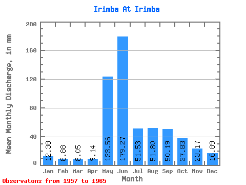
| Statistic | Jan | Feb | Mar | Apr | May | Jun | Jul | Aug | Sep | Oct | Nov | Dec | Annual |
|---|---|---|---|---|---|---|---|---|---|---|---|---|---|
| Mean | 12.38 | 8.96 | 8.05 | 9.13 | 123.54 | 179.27 | 51.52 | 51.79 | 50.19 | 37.83 | 23.17 | 16.89 | 571.84 |
| Standard Deviation | 2.73 | 2.61 | 2.67 | 2.82 | 36.56 | 88.07 | 15.24 | 23.89 | 16.46 | 12.27 | 6.66 | 3.88 | 116.53 |
| Min | 9.26 | 4.43 | 4.70 | 5.06 | 66.45 | 85.12 | 28.60 | 23.97 | 27.52 | 23.38 | 16.29 | 12.20 | 470.74 |
| Max | 17.85 | 11.63 | 11.01 | 12.35 | 171.59 | 374.40 | 74.39 | 91.25 | 72.00 | 55.21 | 36.80 | 24.37 | 805.36 |
| Coefficient of Variation | 0.22 | 0.29 | 0.33 | 0.31 | 0.30 | 0.49 | 0.30 | 0.46 | 0.33 | 0.32 | 0.29 | 0.23 | 0.20 |
 Return to R-Arctic Net Home Page