|
|
|||||||||||||||||
| Point ID: 8360 | Downloads | Plots | Site Data | Code: 9361 |
|
|
|||||||||||||||||
| Download | |
|---|---|
| Site Descriptor Information | Site Time Series Data |
| Link to all available data | |
| View: | Time Series | All |
| Units: | m3/s |
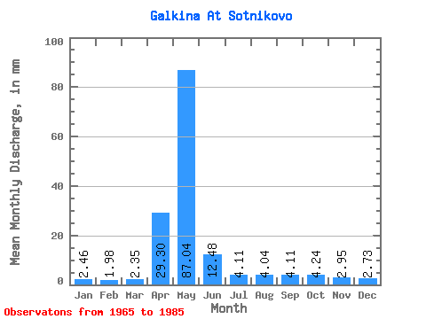
| Statistic | Jan | Feb | Mar | Apr | May | Jun | Jul | Aug | Sep | Oct | Nov | Dec | Annual |
|---|---|---|---|---|---|---|---|---|---|---|---|---|---|
| Mean | 2.46 | 2.00 | 2.35 | 29.30 | 87.03 | 12.48 | 4.11 | 4.04 | 4.11 | 4.24 | 2.95 | 2.73 | 156.74 |
| Standard Deviation | 0.39 | 0.37 | 0.36 | 26.74 | 53.57 | 5.46 | 1.67 | 1.49 | 1.36 | 1.88 | 0.49 | 0.69 | 42.09 |
| Min | 1.58 | 1.44 | 1.73 | 2.51 | 13.61 | 4.32 | 2.74 | 2.81 | 2.93 | 2.95 | 2.37 | 1.58 | 57.55 |
| Max | 3.17 | 2.69 | 2.88 | 73.16 | 188.61 | 24.53 | 10.65 | 8.93 | 8.78 | 10.80 | 3.97 | 5.18 | 239.53 |
| Coefficient of Variation | 0.16 | 0.18 | 0.15 | 0.91 | 0.62 | 0.44 | 0.41 | 0.37 | 0.33 | 0.44 | 0.17 | 0.25 | 0.27 |
 Return to R-Arctic Net Home Page