|
|
|||||||||||||||||
| Point ID: 8350 | Downloads | Plots | Site Data | Code: 9319 |
|
|
|||||||||||||||||
| Download | |
|---|---|
| Site Descriptor Information | Site Time Series Data |
| Link to all available data | |
| View: | Time Series | All |
| Units: | m3/s |
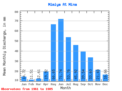
| Statistic | Jan | Feb | Mar | Apr | May | Jun | Jul | Aug | Sep | Oct | Nov | Dec | Annual |
|---|---|---|---|---|---|---|---|---|---|---|---|---|---|
| Mean | 14.72 | 11.61 | 12.60 | 19.92 | 66.64 | 71.74 | 53.75 | 45.92 | 39.54 | 33.60 | 21.43 | 16.66 | 406.61 |
| Standard Deviation | 3.22 | 3.19 | 2.49 | 5.69 | 18.70 | 28.55 | 17.16 | 15.77 | 12.69 | 10.82 | 6.15 | 4.21 | 86.98 |
| Min | 9.52 | 6.62 | 7.67 | 12.27 | 34.71 | 38.53 | 28.02 | 19.74 | 22.87 | 19.11 | 12.51 | 10.64 | 256.65 |
| Max | 24.04 | 18.92 | 18.18 | 31.44 | 113.36 | 145.78 | 91.07 | 85.34 | 73.04 | 65.60 | 35.44 | 26.30 | 672.35 |
| Coefficient of Variation | 0.22 | 0.28 | 0.20 | 0.29 | 0.28 | 0.40 | 0.32 | 0.34 | 0.32 | 0.32 | 0.29 | 0.25 | 0.21 |
 Return to R-Arctic Net Home Page