|
|
|||||||||||||||||
| Point ID: 8348 | Downloads | Plots | Site Data | Code: 9312 |
|
|
|||||||||||||||||
| Download | |
|---|---|
| Site Descriptor Information | Site Time Series Data |
| Link to all available data | |
| View: | Time Series | All |
| Units: | m3/s |
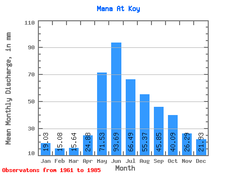
| Statistic | Jan | Feb | Mar | Apr | May | Jun | Jul | Aug | Sep | Oct | Nov | Dec | Annual |
|---|---|---|---|---|---|---|---|---|---|---|---|---|---|
| Mean | 19.03 | 15.21 | 15.64 | 24.88 | 71.52 | 93.69 | 66.47 | 55.37 | 45.85 | 40.08 | 26.29 | 21.93 | 494.73 |
| Standard Deviation | 2.78 | 2.47 | 2.26 | 6.57 | 16.49 | 35.73 | 17.47 | 14.96 | 11.32 | 9.25 | 5.03 | 3.67 | 77.30 |
| Min | 13.85 | 11.09 | 10.65 | 13.84 | 47.09 | 49.12 | 41.92 | 31.95 | 29.16 | 27.77 | 15.24 | 16.74 | 360.73 |
| Max | 23.28 | 20.31 | 19.55 | 40.13 | 114.12 | 187.77 | 108.79 | 100.42 | 70.40 | 67.03 | 36.52 | 28.91 | 673.86 |
| Coefficient of Variation | 0.15 | 0.16 | 0.14 | 0.26 | 0.23 | 0.38 | 0.26 | 0.27 | 0.25 | 0.23 | 0.19 | 0.17 | 0.16 |
 Return to R-Arctic Net Home Page