|
|
|||||||||||||||||
| Point ID: 8341 | Downloads | Plots | Site Data | Code: 9303 |
|
|
|||||||||||||||||
| Download | |
|---|---|
| Site Descriptor Information | Site Time Series Data |
| Link to all available data | |
| View: | Time Series | All |
| Units: | m3/s |
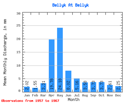
| Statistic | Jan | Feb | Mar | Apr | May | Jun | Jul | Aug | Sep | Oct | Nov | Dec | Annual |
|---|---|---|---|---|---|---|---|---|---|---|---|---|---|
| Mean | 2.02 | 1.57 | 3.31 | 19.77 | 24.18 | 8.02 | 5.16 | 3.58 | 3.72 | 3.73 | 2.61 | 2.25 | 79.74 |
| Standard Deviation | 0.69 | 0.64 | 2.28 | 7.48 | 29.80 | 4.08 | 2.33 | 1.11 | 0.71 | 0.67 | 0.69 | 0.63 | 38.59 |
| Min | 1.32 | 0.29 | 1.67 | 11.95 | 7.91 | 3.90 | 2.64 | 2.15 | 2.35 | 2.29 | 1.34 | 1.32 | 47.90 |
| Max | 3.89 | 2.34 | 9.02 | 37.47 | 113.09 | 17.53 | 9.99 | 5.41 | 4.90 | 4.79 | 3.83 | 3.33 | 186.69 |
| Coefficient of Variation | 0.34 | 0.41 | 0.69 | 0.38 | 1.23 | 0.51 | 0.45 | 0.31 | 0.19 | 0.18 | 0.26 | 0.28 | 0.48 |
 Return to R-Arctic Net Home Page