|
|
|||||||||||||||||
| Point ID: 8339 | Downloads | Plots | Site Data | Code: 9301 |
|
|
|||||||||||||||||
| Download | |
|---|---|
| Site Descriptor Information | Site Time Series Data |
| Link to all available data | |
| View: | Time Series | All |
| Units: | m3/s |
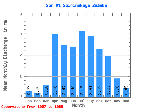
| Statistic | Jan | Feb | Mar | Apr | May | Jun | Jul | Aug | Sep | Oct | Nov | Dec | Annual |
|---|---|---|---|---|---|---|---|---|---|---|---|---|---|
| Mean | 0.28 | 0.21 | 0.56 | 3.00 | 2.48 | 2.40 | 3.15 | 2.91 | 2.29 | 1.98 | 0.90 | 0.45 | 20.22 |
| Standard Deviation | 0.21 | 0.24 | 0.70 | 2.03 | 0.94 | 0.82 | 1.66 | 0.92 | 0.73 | 0.55 | 0.34 | 0.25 | 4.68 |
| Min | 0.01 | 0.00 | 0.00 | 0.91 | 1.21 | 0.91 | 1.81 | 1.38 | 1.33 | 0.94 | 0.42 | 0.12 | 14.58 |
| Max | 0.77 | 0.90 | 2.91 | 8.52 | 4.51 | 3.94 | 9.51 | 5.06 | 4.31 | 2.97 | 1.54 | 1.21 | 30.45 |
| Coefficient of Variation | 0.74 | 1.18 | 1.24 | 0.68 | 0.38 | 0.34 | 0.53 | 0.32 | 0.32 | 0.28 | 0.37 | 0.56 | 0.23 |
 Return to R-Arctic Net Home Page