|
|
|||||||||||||||||
| Point ID: 8323 | Downloads | Plots | Site Data | Code: 9235 |
|
|
|||||||||||||||||
| Download | |
|---|---|
| Site Descriptor Information | Site Time Series Data |
| Link to all available data | |
| View: | Time Series | All |
| Units: | m3/s |
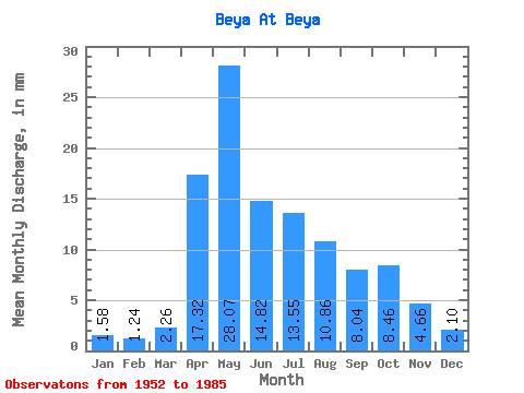
| Statistic | Jan | Feb | Mar | Apr | May | Jun | Jul | Aug | Sep | Oct | Nov | Dec | Annual |
|---|---|---|---|---|---|---|---|---|---|---|---|---|---|
| Mean | 1.58 | 1.25 | 2.26 | 17.32 | 28.06 | 14.82 | 13.55 | 10.85 | 8.04 | 8.46 | 4.66 | 2.11 | 112.22 |
| Standard Deviation | 0.88 | 0.68 | 1.46 | 9.07 | 13.99 | 9.31 | 16.41 | 11.47 | 4.65 | 4.98 | 3.06 | 1.20 | 45.56 |
| Min | 0.48 | 0.43 | 0.39 | 4.11 | 11.03 | 2.56 | 1.70 | 1.89 | 2.92 | 3.02 | 1.09 | 0.58 | 38.52 |
| Max | 4.43 | 3.78 | 6.04 | 33.86 | 64.22 | 41.98 | 75.34 | 66.76 | 21.17 | 26.78 | 15.24 | 4.34 | 238.61 |
| Coefficient of Variation | 0.55 | 0.55 | 0.65 | 0.52 | 0.50 | 0.63 | 1.21 | 1.06 | 0.58 | 0.59 | 0.66 | 0.57 | 0.41 |
 Return to R-Arctic Net Home Page