|
|
|||||||||||||||||
| Point ID: 8322 | Downloads | Plots | Site Data | Code: 9233 |
|
|
|||||||||||||||||
| Download | |
|---|---|
| Site Descriptor Information | Site Time Series Data |
| Link to all available data | |
| View: | Time Series | All |
| Units: | m3/s |
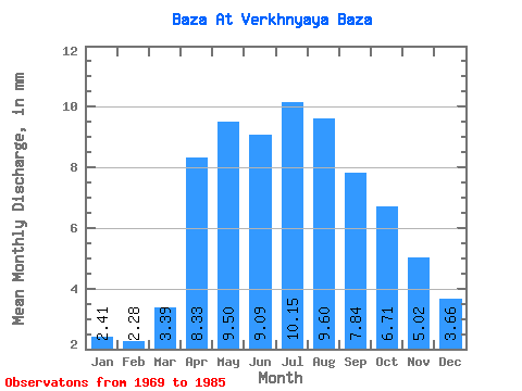
| Statistic | Jan | Feb | Mar | Apr | May | Jun | Jul | Aug | Sep | Oct | Nov | Dec | Annual |
|---|---|---|---|---|---|---|---|---|---|---|---|---|---|
| Mean | 2.41 | 2.31 | 3.39 | 8.33 | 9.50 | 9.09 | 10.15 | 9.60 | 7.85 | 6.71 | 5.02 | 3.66 | 77.52 |
| Standard Deviation | 1.04 | 1.32 | 1.23 | 3.47 | 3.83 | 5.31 | 5.52 | 4.49 | 3.41 | 2.29 | 1.77 | 1.84 | 28.15 |
| Min | 0.34 | 0.07 | 0.06 | 2.88 | 5.26 | 4.61 | 4.36 | 4.07 | 4.03 | 3.27 | 2.11 | 1.09 | 46.27 |
| Max | 4.26 | 4.79 | 5.26 | 15.26 | 18.45 | 21.41 | 22.91 | 20.83 | 15.36 | 10.81 | 7.97 | 7.54 | 144.07 |
| Coefficient of Variation | 0.43 | 0.57 | 0.36 | 0.42 | 0.40 | 0.58 | 0.54 | 0.47 | 0.43 | 0.34 | 0.35 | 0.50 | 0.36 |
 Return to R-Arctic Net Home Page