|
|
|||||||||||||||||
| Point ID: 8313 | Downloads | Plots | Site Data | Code: 9196 |
|
|
|||||||||||||||||
| Download | |
|---|---|
| Site Descriptor Information | Site Time Series Data |
| Link to all available data | |
| View: | Time Series | All |
| Units: | m3/s |
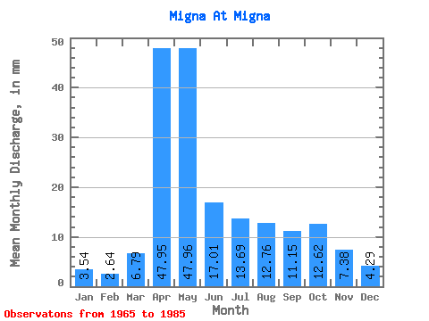
| Statistic | Jan | Feb | Mar | Apr | May | Jun | Jul | Aug | Sep | Oct | Nov | Dec | Annual |
|---|---|---|---|---|---|---|---|---|---|---|---|---|---|
| Mean | 3.53 | 2.66 | 6.79 | 47.96 | 47.95 | 17.00 | 13.68 | 12.76 | 11.15 | 12.61 | 7.39 | 4.29 | 187.65 |
| Standard Deviation | 1.55 | 1.23 | 4.19 | 21.11 | 25.89 | 8.40 | 16.36 | 10.64 | 6.95 | 8.19 | 4.45 | 1.94 | 58.87 |
| Min | 0.76 | 0.91 | 1.69 | 16.92 | 10.85 | 5.32 | 3.52 | 3.10 | 3.41 | 3.67 | 2.59 | 2.11 | 101.19 |
| Max | 7.75 | 5.78 | 16.07 | 96.45 | 115.86 | 34.52 | 71.18 | 36.65 | 25.51 | 30.73 | 20.19 | 9.58 | 305.36 |
| Coefficient of Variation | 0.44 | 0.46 | 0.62 | 0.44 | 0.54 | 0.49 | 1.20 | 0.83 | 0.62 | 0.65 | 0.60 | 0.45 | 0.31 |
 Return to R-Arctic Net Home Page