|
|
|||||||||||||||||
| Point ID: 8306 | Downloads | Plots | Site Data | Code: 9183 |
|
|
|||||||||||||||||
| Download | |
|---|---|
| Site Descriptor Information | Site Time Series Data |
| Link to all available data | |
| View: | Time Series | All |
| Units: | m3/s |
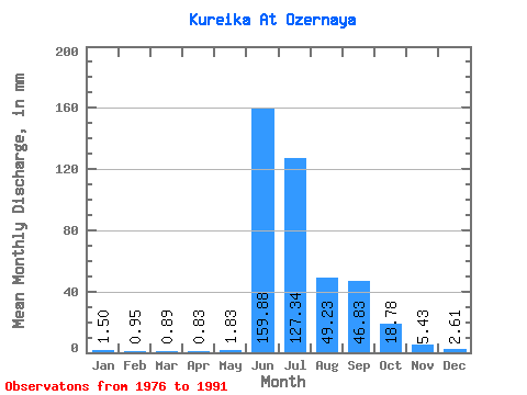
| Statistic | Jan | Feb | Mar | Apr | May | Jun | Jul | Aug | Sep | Oct | Nov | Dec | Annual |
|---|---|---|---|---|---|---|---|---|---|---|---|---|---|
| Mean | 1.50 | 0.95 | 0.90 | 0.83 | 1.83 | 159.88 | 127.32 | 49.22 | 46.83 | 18.77 | 5.42 | 2.61 | 403.84 |
| Standard Deviation | 0.46 | 0.39 | 0.30 | 0.20 | 1.65 | 66.39 | 66.11 | 24.46 | 18.51 | 9.95 | 2.66 | 1.16 | 63.37 |
| Min | 0.70 | 0.43 | 0.53 | 0.61 | 0.80 | 33.39 | 58.52 | 20.49 | 14.02 | 8.54 | 2.41 | 1.58 | 292.32 |
| Max | 2.57 | 1.88 | 1.60 | 1.34 | 7.27 | 299.79 | 285.91 | 89.68 | 82.65 | 50.32 | 13.65 | 6.33 | 548.25 |
| Coefficient of Variation | 0.31 | 0.41 | 0.33 | 0.24 | 0.91 | 0.41 | 0.52 | 0.50 | 0.40 | 0.53 | 0.49 | 0.44 | 0.16 |
 Return to R-Arctic Net Home Page