|
|
|||||||||||||||||
| Point ID: 8305 | Downloads | Plots | Site Data | Code: 9182 |
|
|
|||||||||||||||||
| Download | |
|---|---|
| Site Descriptor Information | Site Time Series Data |
| Link to all available data | |
| View: | Time Series | All |
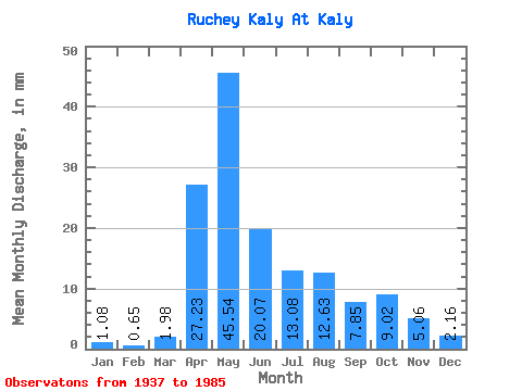
| Units: | m3/s |
| Statistic | Jan | Feb | Mar | Apr | May | Jun | Jul | Aug | Sep | Oct | Nov | Dec | Annual |
|---|---|---|---|---|---|---|---|---|---|---|---|---|---|
| Mean | 1.11 | 0.64 | 1.98 | 27.20 | 45.51 | 20.07 | 13.10 | 12.60 | 7.87 | 9.01 | 5.07 | 2.12 | 152.57 |
| Standard Deviation | 1.26 | 1.03 | 2.45 | 16.77 | 22.85 | 11.76 | 17.46 | 16.77 | 6.69 | 6.34 | 3.90 | 1.95 | 53.62 |
| Min | 0.00 | 0.00 | 0.00 | 8.64 | 12.68 | 1.48 | 1.89 | 1.53 | 1.54 | 1.44 | 1.31 | 0.00 | 61.81 |
| Max | 5.32 | 4.35 | 7.75 | 72.49 | 107.30 | 48.87 | 82.05 | 74.89 | 30.55 | 29.76 | 17.45 | 8.12 | 259.81 |
| Coefficient of Variation | 1.13 | 1.62 | 1.24 | 0.62 | 0.50 | 0.59 | 1.33 | 1.33 | 0.85 | 0.70 | 0.77 | 0.92 | 0.35 |
 Return to R-Arctic Net Home Page