|
|
|||||||||||||||||
| Point ID: 83 | Downloads | Plots | Site Data | Code: 05AD002 |
|
|
|||||||||||||||||
| Download | |
|---|---|
| Site Descriptor Information | Site Time Series Data |
| Link to all available data | |
| View: | Time Series | All |
| Units: | m3/s |
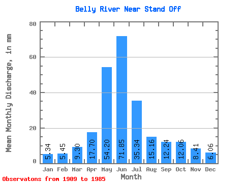
| Statistic | Jan | Feb | Mar | Apr | May | Jun | Jul | Aug | Sep | Oct | Nov | Dec | Annual |
|---|---|---|---|---|---|---|---|---|---|---|---|---|---|
| Mean | 4.99 | 5.13 | 8.69 | 16.53 | 50.60 | 67.10 | 33.00 | 14.16 | 11.43 | 11.26 | 7.86 | 5.66 | 226.54 |
| Standard Deviation | 2.46 | 2.94 | 6.38 | 9.69 | 21.00 | 37.82 | 21.77 | 9.77 | 10.93 | 8.87 | 3.84 | 2.92 | 93.13 |
| Min | 1.29 | 1.53 | 1.96 | 1.65 | 2.26 | 4.58 | 2.59 | 2.08 | 1.35 | 0.97 | 1.28 | 1.88 | 44.88 |
| Max | 13.79 | 20.77 | 39.40 | 47.77 | 100.92 | 185.30 | 88.09 | 38.07 | 57.84 | 36.30 | 16.02 | 17.77 | 488.20 |
| Coefficient of Variation | 0.49 | 0.57 | 0.73 | 0.59 | 0.41 | 0.56 | 0.66 | 0.69 | 0.96 | 0.79 | 0.49 | 0.52 | 0.41 |
 Return to R-Arctic Net Home Page