|
|
|||||||||||||||||
| Point ID: 8293 | Downloads | Plots | Site Data | Code: 9140 |
|
|
|||||||||||||||||
| Download | |
|---|---|
| Site Descriptor Information | Site Time Series Data |
| Link to all available data | |
| View: | Time Series | All |
| Units: | m3/s |
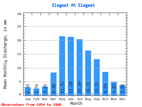
| Statistic | Jan | Feb | Mar | Apr | May | Jun | Jul | Aug | Sep | Oct | Nov | Dec | Annual |
|---|---|---|---|---|---|---|---|---|---|---|---|---|---|
| Mean | 2.95 | 2.58 | 3.26 | 8.37 | 21.41 | 21.28 | 20.39 | 16.31 | 13.21 | 8.59 | 4.87 | 3.85 | 126.59 |
| Standard Deviation | 0.58 | 0.50 | 0.43 | 2.13 | 9.07 | 11.63 | 11.40 | 6.10 | 3.50 | 1.86 | 1.04 | 0.82 | 32.30 |
| Min | 1.59 | 1.75 | 2.75 | 4.84 | 6.40 | 7.27 | 5.85 | 7.84 | 8.71 | 6.54 | 3.19 | 2.05 | 89.05 |
| Max | 4.19 | 3.84 | 4.02 | 11.35 | 38.03 | 50.26 | 48.75 | 28.41 | 22.39 | 13.20 | 7.42 | 5.65 | 210.70 |
| Coefficient of Variation | 0.20 | 0.19 | 0.13 | 0.25 | 0.42 | 0.55 | 0.56 | 0.37 | 0.27 | 0.22 | 0.21 | 0.21 | 0.26 |
 Return to R-Arctic Net Home Page