|
|
|||||||||||||||||
| Point ID: 8274 | Downloads | Plots | Site Data | Code: 8394 |
|
|
|||||||||||||||||
| Download | |
|---|---|
| Site Descriptor Information | Site Time Series Data |
| Link to all available data | |
| View: | Time Series | All |
| Units: | m3/s |
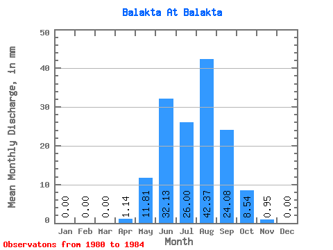
| Statistic | Jan | Feb | Mar | Apr | May | Jun | Jul | Aug | Sep | Oct | Nov | Dec | Annual |
|---|---|---|---|---|---|---|---|---|---|---|---|---|---|
| Mean | 0.00 | 0.00 | 0.00 | 1.14 | 11.80 | 32.13 | 26.00 | 42.37 | 24.09 | 8.54 | 0.95 | 0.00 | 151.70 |
| Standard Deviation | 0.00 | 0.00 | 0.00 | 1.51 | 0.71 | 37.00 | 21.39 | 27.34 | 13.52 | 1.44 | 0.34 | 0.00 | 42.45 |
| Min | 0.00 | 0.00 | 0.00 | 0.10 | 11.27 | 12.42 | 12.50 | 23.77 | 15.12 | 6.70 | 0.66 | 0.00 | 114.86 |
| Max | 0.00 | 0.00 | 0.00 | 3.35 | 12.83 | 87.59 | 50.66 | 73.76 | 39.64 | 10.15 | 1.40 | 0.00 | 198.12 |
| Coefficient of Variation | 1.33 | 0.06 | 1.15 | 0.82 | 0.65 | 0.56 | 0.17 | 0.36 | 0.28 |
 Return to R-Arctic Net Home Page