|
|
|||||||||||||||||
| Point ID: 8262 | Downloads | Plots | Site Data | Code: 8369 |
|
|
|||||||||||||||||
| Download | |
|---|---|
| Site Descriptor Information | Site Time Series Data |
| Link to all available data | |
| View: | Time Series | All |
| Units: | m3/s |
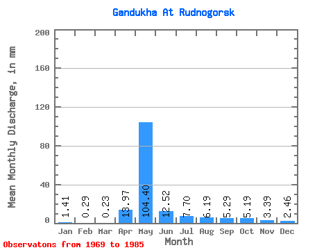
| Statistic | Jan | Feb | Mar | Apr | May | Jun | Jul | Aug | Sep | Oct | Nov | Dec | Annual |
|---|---|---|---|---|---|---|---|---|---|---|---|---|---|
| Mean | 1.40 | 0.30 | 0.21 | 13.96 | 104.37 | 12.51 | 7.69 | 6.21 | 5.29 | 5.18 | 3.38 | 2.44 | 150.83 |
| Standard Deviation | 1.27 | 0.80 | 0.68 | 18.08 | 34.83 | 8.20 | 4.17 | 3.72 | 2.86 | 3.10 | 2.08 | 1.74 | 50.70 |
| Min | 0.00 | 0.00 | 0.00 | 0.00 | 42.36 | 2.87 | 3.46 | 1.00 | 0.88 | 0.50 | 0.31 | 0.14 | 56.76 |
| Max | 3.51 | 2.57 | 2.14 | 50.25 | 159.41 | 34.38 | 18.22 | 13.21 | 9.26 | 10.02 | 6.61 | 5.46 | 219.52 |
| Coefficient of Variation | 0.90 | 2.69 | 3.16 | 1.29 | 0.33 | 0.66 | 0.54 | 0.60 | 0.54 | 0.60 | 0.62 | 0.71 | 0.34 |
 Return to R-Arctic Net Home Page