|
|
|||||||||||||||||
| Point ID: 8255 | Downloads | Plots | Site Data | Code: 8350 |
|
|
|||||||||||||||||
| Download | |
|---|---|
| Site Descriptor Information | Site Time Series Data |
| Link to all available data | |
| View: | Time Series | All |
| Units: | m3/s |
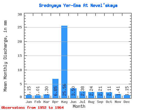
| Statistic | Jan | Feb | Mar | Apr | May | Jun | Jul | Aug | Sep | Oct | Nov | Dec | Annual |
|---|---|---|---|---|---|---|---|---|---|---|---|---|---|
| Mean | 1.16 | 1.02 | 1.30 | 6.85 | 25.55 | 3.51 | 2.37 | 2.25 | 2.21 | 2.10 | 1.40 | 1.16 | 51.53 |
| Standard Deviation | 0.29 | 0.50 | 0.54 | 5.16 | 10.23 | 1.07 | 0.65 | 0.73 | 0.73 | 0.44 | 0.48 | 0.47 | 11.76 |
| Min | 0.74 | 0.33 | 0.36 | 1.48 | 6.04 | 2.01 | 1.56 | 1.43 | 1.39 | 1.43 | 0.77 | 0.49 | 34.51 |
| Max | 1.64 | 2.06 | 2.45 | 16.43 | 42.06 | 6.02 | 3.40 | 3.96 | 3.47 | 2.83 | 2.56 | 1.85 | 68.56 |
| Coefficient of Variation | 0.25 | 0.49 | 0.41 | 0.75 | 0.40 | 0.30 | 0.27 | 0.32 | 0.33 | 0.21 | 0.35 | 0.41 | 0.23 |
 Return to R-Arctic Net Home Page