|
|
|||||||||||||||||
| Point ID: 8251 | Downloads | Plots | Site Data | Code: 8338 |
|
|
|||||||||||||||||
| Download | |
|---|---|
| Site Descriptor Information | Site Time Series Data |
| Link to all available data | |
| View: | Time Series | All |
| Units: | m3/s |
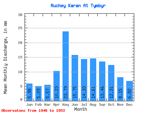
| Statistic | Jan | Feb | Mar | Apr | May | Jun | Jul | Aug | Sep | Oct | Nov | Dec | Annual |
|---|---|---|---|---|---|---|---|---|---|---|---|---|---|
| Mean | 5.98 | 5.10 | 5.54 | 10.24 | 23.79 | 15.76 | 14.34 | 14.62 | 13.47 | 12.30 | 8.14 | 6.82 | 137.21 |
| Standard Deviation | 1.51 | 1.02 | 0.94 | 9.68 | 16.67 | 12.65 | 5.35 | 6.01 | 5.00 | 5.65 | 3.35 | 2.15 | 57.23 |
| Min | 4.17 | 3.49 | 4.03 | 0.00 | 0.00 | 0.00 | 9.74 | 8.39 | 8.12 | 7.69 | 5.09 | 4.08 | 69.27 |
| Max | 8.35 | 6.34 | 6.54 | 26.26 | 41.04 | 34.34 | 22.95 | 22.95 | 21.54 | 22.95 | 14.14 | 10.43 | 210.06 |
| Coefficient of Variation | 0.25 | 0.20 | 0.17 | 0.94 | 0.70 | 0.80 | 0.37 | 0.41 | 0.37 | 0.46 | 0.41 | 0.32 | 0.42 |
 Return to R-Arctic Net Home Page