|
|
|||||||||||||||||
| Point ID: 8247 | Downloads | Plots | Site Data | Code: 8320 |
|
|
|||||||||||||||||
| Download | |
|---|---|
| Site Descriptor Information | Site Time Series Data |
| Link to all available data | |
| View: | Time Series | All |
| Units: | m3/s |
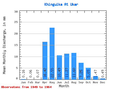
| Statistic | Jan | Feb | Mar | Apr | May | Jun | Jul | Aug | Sep | Oct | Nov | Dec | Annual |
|---|---|---|---|---|---|---|---|---|---|---|---|---|---|
| Mean | 0.16 | 0.07 | 0.08 | 16.42 | 22.54 | 10.49 | 11.26 | 11.61 | 7.25 | 5.10 | 1.47 | 0.49 | 87.00 |
| Standard Deviation | 0.14 | 0.09 | 0.16 | 10.68 | 14.50 | 5.24 | 8.07 | 11.86 | 6.07 | 3.45 | 1.07 | 0.51 | 36.99 |
| Min | 0.00 | 0.00 | 0.00 | 2.17 | 8.30 | 4.20 | 3.29 | 1.50 | 1.88 | 1.72 | 0.31 | 0.01 | 44.22 |
| Max | 0.40 | 0.24 | 0.54 | 37.94 | 48.32 | 22.23 | 31.57 | 45.86 | 20.64 | 12.34 | 3.62 | 1.72 | 147.48 |
| Coefficient of Variation | 0.90 | 1.39 | 1.99 | 0.65 | 0.64 | 0.50 | 0.72 | 1.02 | 0.84 | 0.68 | 0.73 | 1.05 | 0.42 |
 Return to R-Arctic Net Home Page