|
|
|||||||||||||||||
| Point ID: 8242 | Downloads | Plots | Site Data | Code: 8315 |
|
|
|||||||||||||||||
| Download | |
|---|---|
| Site Descriptor Information | Site Time Series Data |
| Link to all available data | |
| View: | Time Series | All |
| Units: | m3/s |
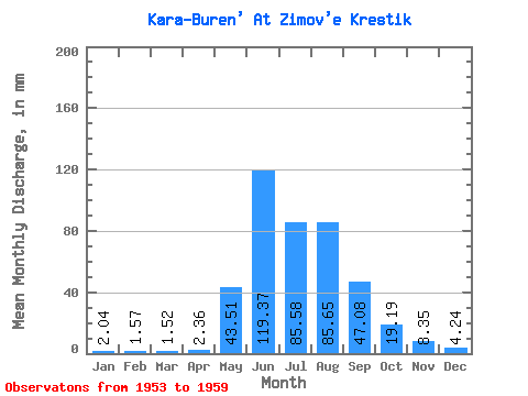
| Statistic | Jan | Feb | Mar | Apr | May | Jun | Jul | Aug | Sep | Oct | Nov | Dec | Annual |
|---|---|---|---|---|---|---|---|---|---|---|---|---|---|
| Mean | 2.04 | 1.58 | 1.52 | 2.36 | 43.50 | 119.37 | 85.56 | 85.64 | 47.08 | 19.19 | 8.35 | 4.24 | 418.77 |
| Standard Deviation | 0.61 | 0.35 | 0.35 | 0.26 | 19.99 | 39.61 | 38.64 | 19.60 | 13.29 | 3.42 | 1.84 | 0.93 | 66.58 |
| Min | 1.04 | 1.01 | 0.98 | 2.12 | 6.48 | 66.22 | 46.05 | 64.34 | 28.45 | 15.23 | 5.69 | 2.37 | 340.78 |
| Max | 2.81 | 1.89 | 2.01 | 2.88 | 69.24 | 177.01 | 157.25 | 119.20 | 69.22 | 24.33 | 10.37 | 5.14 | 486.17 |
| Coefficient of Variation | 0.30 | 0.22 | 0.23 | 0.11 | 0.46 | 0.33 | 0.45 | 0.23 | 0.28 | 0.18 | 0.22 | 0.22 | 0.16 |
 Return to R-Arctic Net Home Page