|
|
|||||||||||||||||
| Point ID: 8233 | Downloads | Plots | Site Data | Code: 8280 |
|
|
|||||||||||||||||
| Download | |
|---|---|
| Site Descriptor Information | Site Time Series Data |
| Link to all available data | |
| View: | Time Series | All |
| Units: | m3/s |
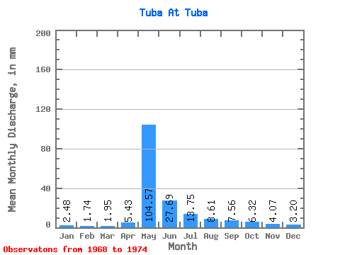
| Statistic | Jan | Feb | Mar | Apr | May | Jun | Jul | Aug | Sep | Oct | Nov | Dec | Annual |
|---|---|---|---|---|---|---|---|---|---|---|---|---|---|
| Mean | 2.48 | 1.76 | 1.95 | 5.43 | 104.55 | 27.69 | 13.75 | 8.60 | 7.56 | 6.32 | 4.07 | 3.20 | 179.32 |
| Standard Deviation | 1.82 | 1.36 | 1.36 | 4.23 | 29.89 | 13.69 | 6.24 | 3.27 | 2.32 | 2.06 | 1.78 | 1.78 | 52.29 |
| Min | 1.01 | 0.70 | 0.68 | 1.53 | 63.43 | 13.62 | 5.80 | 4.45 | 5.68 | 4.30 | 1.66 | 1.58 | 138.51 |
| Max | 4.90 | 3.94 | 3.54 | 12.21 | 140.66 | 44.77 | 22.86 | 13.66 | 11.51 | 9.12 | 6.15 | 5.50 | 238.27 |
| Coefficient of Variation | 0.73 | 0.78 | 0.70 | 0.78 | 0.29 | 0.49 | 0.45 | 0.38 | 0.31 | 0.33 | 0.44 | 0.56 | 0.29 |
 Return to R-Arctic Net Home Page