|
|
|||||||||||||||||
| Point ID: 8230 | Downloads | Plots | Site Data | Code: 8276 |
|
|
|||||||||||||||||
| Download | |
|---|---|
| Site Descriptor Information | Site Time Series Data |
| Link to all available data | |
| View: | Time Series | All |
| Units: | m3/s |
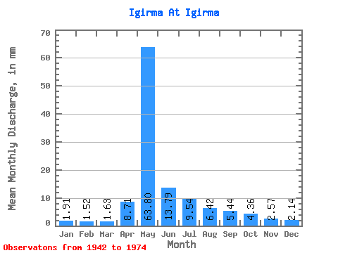
| Statistic | Jan | Feb | Mar | Apr | May | Jun | Jul | Aug | Sep | Oct | Nov | Dec | Annual |
|---|---|---|---|---|---|---|---|---|---|---|---|---|---|
| Mean | 1.91 | 1.53 | 1.63 | 8.71 | 63.79 | 13.79 | 9.54 | 6.42 | 5.44 | 4.36 | 2.57 | 2.13 | 120.25 |
| Standard Deviation | 0.64 | 0.57 | 0.60 | 9.14 | 22.17 | 5.26 | 5.93 | 2.47 | 1.56 | 1.20 | 0.83 | 0.71 | 24.09 |
| Min | 0.92 | 0.63 | 0.59 | 1.20 | 19.85 | 5.43 | 3.56 | 2.59 | 2.35 | 1.83 | 0.96 | 0.78 | 68.98 |
| Max | 3.37 | 2.60 | 3.08 | 37.14 | 112.98 | 25.69 | 26.30 | 11.84 | 9.72 | 6.70 | 4.62 | 3.71 | 173.29 |
| Coefficient of Variation | 0.33 | 0.37 | 0.37 | 1.05 | 0.35 | 0.38 | 0.62 | 0.38 | 0.29 | 0.28 | 0.32 | 0.33 | 0.20 |
 Return to R-Arctic Net Home Page