|
|
|||||||||||||||||
| Point ID: 8223 | Downloads | Plots | Site Data | Code: 8265 |
|
|
|||||||||||||||||
| Download | |
|---|---|
| Site Descriptor Information | Site Time Series Data |
| Link to all available data | |
| View: | Time Series | All |
| Units: | m3/s |
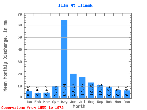
| Statistic | Jan | Feb | Mar | Apr | May | Jun | Jul | Aug | Sep | Oct | Nov | Dec | Annual |
|---|---|---|---|---|---|---|---|---|---|---|---|---|---|
| Mean | 5.55 | 4.54 | 4.62 | 9.75 | 64.03 | 20.17 | 17.06 | 12.91 | 10.76 | 8.94 | 6.74 | 6.46 | 172.31 |
| Standard Deviation | 0.97 | 0.84 | 0.83 | 7.85 | 17.18 | 7.73 | 6.95 | 3.12 | 2.69 | 2.31 | 1.31 | 1.13 | 26.27 |
| Min | 4.06 | 3.31 | 3.13 | 4.54 | 21.18 | 11.68 | 7.55 | 7.82 | 6.60 | 5.04 | 4.67 | 4.38 | 132.85 |
| Max | 7.27 | 6.38 | 5.79 | 33.15 | 90.46 | 32.25 | 34.41 | 19.31 | 15.52 | 12.86 | 8.53 | 8.10 | 206.12 |
| Coefficient of Variation | 0.17 | 0.19 | 0.18 | 0.81 | 0.27 | 0.38 | 0.41 | 0.24 | 0.25 | 0.26 | 0.19 | 0.17 | 0.15 |
 Return to R-Arctic Net Home Page