|
|
|||||||||||||||||
| Point ID: 8217 | Downloads | Plots | Site Data | Code: 8245 |
|
|
|||||||||||||||||
| Download | |
|---|---|
| Site Descriptor Information | Site Time Series Data |
| Link to all available data | |
| View: | Time Series | All |
| Units: | m3/s |
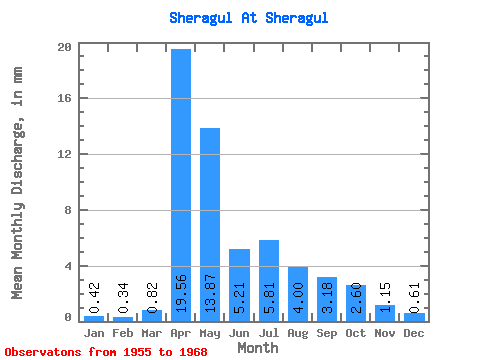
| Statistic | Jan | Feb | Mar | Apr | May | Jun | Jul | Aug | Sep | Oct | Nov | Dec | Annual |
|---|---|---|---|---|---|---|---|---|---|---|---|---|---|
| Mean | 0.42 | 0.33 | 0.83 | 19.55 | 13.87 | 5.21 | 5.81 | 4.00 | 3.18 | 2.59 | 1.15 | 0.61 | 53.90 |
| Standard Deviation | 0.41 | 0.42 | 1.08 | 18.90 | 9.66 | 2.49 | 5.98 | 3.23 | 1.90 | 1.41 | 0.55 | 0.42 | 27.07 |
| Min | 0.00 | 0.00 | 0.00 | 0.90 | 3.98 | 2.16 | 1.59 | 1.43 | 1.28 | 1.25 | 0.23 | 0.00 | 19.48 |
| Max | 1.11 | 1.35 | 4.24 | 52.37 | 35.53 | 10.52 | 21.21 | 11.93 | 7.19 | 6.63 | 2.36 | 1.48 | 115.38 |
| Coefficient of Variation | 0.97 | 1.27 | 1.30 | 0.97 | 0.70 | 0.48 | 1.03 | 0.81 | 0.60 | 0.55 | 0.48 | 0.69 | 0.50 |
 Return to R-Arctic Net Home Page