|
|
|||||||||||||||||
| Point ID: 8212 | Downloads | Plots | Site Data | Code: 8224 |
|
|
|||||||||||||||||
| Download | |
|---|---|
| Site Descriptor Information | Site Time Series Data |
| Link to all available data | |
| View: | Time Series | All |
| Units: | m3/s |
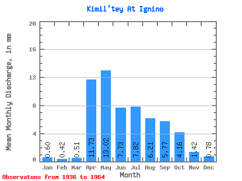
| Statistic | Jan | Feb | Mar | Apr | May | Jun | Jul | Aug | Sep | Oct | Nov | Dec | Annual |
|---|---|---|---|---|---|---|---|---|---|---|---|---|---|
| Mean | 0.60 | 0.42 | 0.51 | 11.73 | 13.02 | 7.73 | 7.82 | 6.21 | 5.76 | 4.16 | 1.42 | 0.79 | 59.57 |
| Standard Deviation | 0.29 | 0.20 | 0.32 | 8.11 | 8.70 | 3.00 | 4.09 | 3.28 | 3.78 | 1.59 | 0.56 | 0.30 | 19.65 |
| Min | 0.21 | 0.12 | 0.16 | 2.28 | 4.51 | 3.14 | 2.27 | 1.73 | 1.66 | 2.12 | 0.60 | 0.40 | 29.02 |
| Max | 1.35 | 0.91 | 1.42 | 34.93 | 50.78 | 14.03 | 18.91 | 14.59 | 18.21 | 8.02 | 3.44 | 1.69 | 109.97 |
| Coefficient of Variation | 0.49 | 0.48 | 0.63 | 0.69 | 0.67 | 0.39 | 0.52 | 0.53 | 0.66 | 0.38 | 0.40 | 0.39 | 0.33 |
 Return to R-Arctic Net Home Page