|
|
|||||||||||||||||
| Point ID: 8199 | Downloads | Plots | Site Data | Code: 8194 |
|
|
|||||||||||||||||
| Download | |
|---|---|
| Site Descriptor Information | Site Time Series Data |
| Link to all available data | |
| View: | Time Series | All |
| Units: | m3/s |
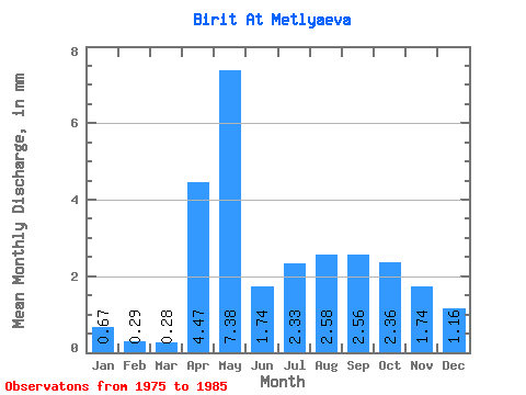
| Statistic | Jan | Feb | Mar | Apr | May | Jun | Jul | Aug | Sep | Oct | Nov | Dec | Annual |
|---|---|---|---|---|---|---|---|---|---|---|---|---|---|
| Mean | 0.65 | 0.28 | 0.29 | 4.46 | 7.39 | 1.75 | 2.33 | 2.59 | 2.58 | 2.36 | 1.75 | 1.15 | 27.43 |
| Standard Deviation | 1.17 | 0.87 | 0.90 | 3.64 | 5.02 | 1.88 | 2.52 | 2.33 | 1.73 | 1.77 | 1.69 | 1.43 | 17.32 |
| Min | 0.00 | 0.00 | 0.00 | 0.41 | 2.26 | 0.68 | 0.64 | 0.60 | 0.79 | 0.60 | 0.00 | 0.00 | 8.63 |
| Max | 3.39 | 2.77 | 2.86 | 10.61 | 16.58 | 6.83 | 8.82 | 7.76 | 5.46 | 5.29 | 5.46 | 4.59 | 59.36 |
| Coefficient of Variation | 1.79 | 3.16 | 3.16 | 0.81 | 0.68 | 1.08 | 1.08 | 0.90 | 0.67 | 0.75 | 0.97 | 1.24 | 0.63 |
 Return to R-Arctic Net Home Page