|
|
|||||||||||||||||
| Point ID: 8194 | Downloads | Plots | Site Data | Code: 8189 |
|
|
|||||||||||||||||
| Download | |
|---|---|
| Site Descriptor Information | Site Time Series Data |
| Link to all available data | |
| View: | Time Series | All |
| Units: | m3/s |
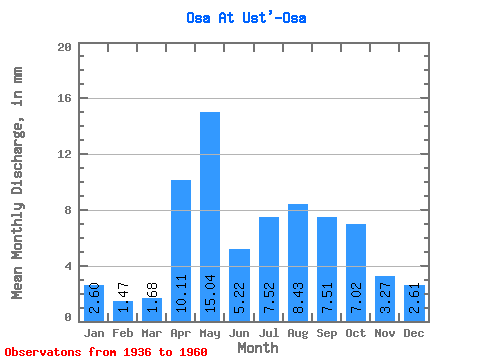
| Statistic | Jan | Feb | Mar | Apr | May | Jun | Jul | Aug | Sep | Oct | Nov | Dec | Annual |
|---|---|---|---|---|---|---|---|---|---|---|---|---|---|
| Mean | 2.60 | 1.48 | 1.68 | 10.11 | 15.04 | 5.22 | 7.52 | 8.43 | 7.51 | 7.02 | 3.27 | 2.61 | 71.98 |
| Standard Deviation | 2.89 | 0.95 | 1.18 | 7.36 | 10.92 | 2.79 | 6.67 | 7.20 | 4.86 | 4.22 | 1.76 | 1.48 | 34.47 |
| Min | 0.34 | 0.25 | 0.17 | 1.85 | 7.15 | 1.99 | 1.72 | 1.39 | 1.16 | 1.21 | 0.71 | 0.45 | 23.23 |
| Max | 15.18 | 3.62 | 4.77 | 29.02 | 49.23 | 15.24 | 28.98 | 29.10 | 20.03 | 14.36 | 7.28 | 5.88 | 151.37 |
| Coefficient of Variation | 1.11 | 0.65 | 0.70 | 0.73 | 0.73 | 0.54 | 0.89 | 0.85 | 0.65 | 0.60 | 0.54 | 0.57 | 0.48 |
 Return to R-Arctic Net Home Page