|
|
|||||||||||||||||
| Point ID: 8193 | Downloads | Plots | Site Data | Code: 8184 |
|
|
|||||||||||||||||
| Download | |
|---|---|
| Site Descriptor Information | Site Time Series Data |
| Link to all available data | |
| View: | Time Series | All |
| Units: | m3/s |
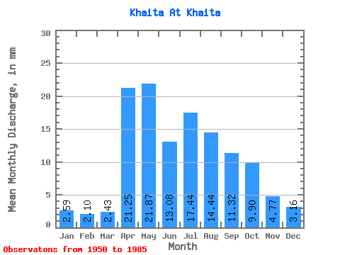
| Statistic | Jan | Feb | Mar | Apr | May | Jun | Jul | Aug | Sep | Oct | Nov | Dec | Annual |
|---|---|---|---|---|---|---|---|---|---|---|---|---|---|
| Mean | 2.59 | 2.11 | 2.43 | 21.25 | 21.87 | 13.09 | 17.43 | 14.44 | 11.33 | 9.89 | 4.77 | 3.15 | 123.25 |
| Standard Deviation | 0.98 | 0.87 | 1.06 | 7.23 | 9.45 | 5.82 | 13.93 | 12.19 | 5.23 | 4.75 | 1.57 | 1.03 | 42.46 |
| Min | 0.95 | 0.79 | 0.98 | 8.84 | 7.76 | 6.93 | 5.23 | 4.85 | 4.11 | 4.74 | 2.20 | 1.78 | 62.61 |
| Max | 5.04 | 4.28 | 4.77 | 40.33 | 43.18 | 35.34 | 75.00 | 65.53 | 29.99 | 29.73 | 9.02 | 5.83 | 233.43 |
| Coefficient of Variation | 0.38 | 0.41 | 0.43 | 0.34 | 0.43 | 0.45 | 0.80 | 0.84 | 0.46 | 0.48 | 0.33 | 0.33 | 0.34 |
 Return to R-Arctic Net Home Page