|
|
|||||||||||||||||
| Point ID: 8191 | Downloads | Plots | Site Data | Code: 8179 |
|
|
|||||||||||||||||
| Download | |
|---|---|
| Site Descriptor Information | Site Time Series Data |
| Link to all available data | |
| View: | Time Series | All |
| Units: | m3/s |
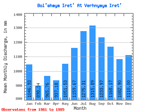
| Statistic | Jan | Feb | Mar | Apr | May | Jun | Jul | Aug | Sep | Oct | Nov | Dec | Annual |
|---|---|---|---|---|---|---|---|---|---|---|---|---|---|
| Mean | 1046.75 | 906.04 | 965.59 | 937.16 | 1051.36 | 1159.63 | 1275.12 | 1315.65 | 1234.02 | 1167.98 | 1082.92 | 1109.85 | 13196.69 |
| Standard Deviation | 76.48 | 45.26 | 32.59 | 30.19 | 41.44 | 74.05 | 88.48 | 88.87 | 87.57 | 85.73 | 90.66 | 96.00 | 602.50 |
| Min | 931.19 | 842.84 | 905.63 | 900.29 | 989.43 | 1009.12 | 1155.02 | 1185.70 | 1068.48 | 1032.38 | 953.72 | 977.18 | 12340.16 |
| Max | 1175.46 | 987.18 | 1042.58 | 1018.99 | 1134.57 | 1276.21 | 1492.32 | 1461.66 | 1345.47 | 1298.11 | 1236.64 | 1236.79 | 14304.39 |
| Coefficient of Variation | 0.07 | 0.05 | 0.03 | 0.03 | 0.04 | 0.06 | 0.07 | 0.07 | 0.07 | 0.07 | 0.08 | 0.09 | 0.05 |
 Return to R-Arctic Net Home Page