|
|
|||||||||||||||||
| Point ID: 8180 | Downloads | Plots | Site Data | Code: 8152 |
|
|
|||||||||||||||||
| Download | |
|---|---|
| Site Descriptor Information | Site Time Series Data |
| Link to all available data | |
| View: | Time Series | All |
| Units: | m3/s |
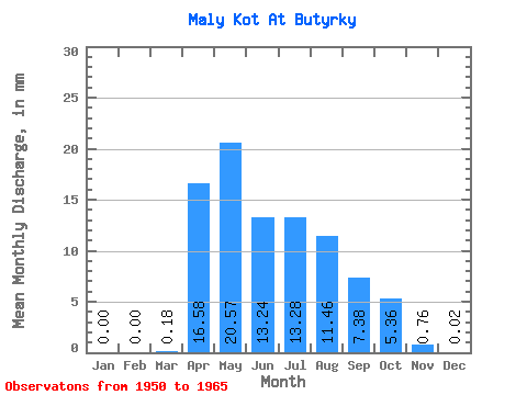
| Statistic | Jan | Feb | Mar | Apr | May | Jun | Jul | Aug | Sep | Oct | Nov | Dec | Annual |
|---|---|---|---|---|---|---|---|---|---|---|---|---|---|
| Mean | 0.00 | 0.00 | 0.18 | 16.59 | 20.57 | 13.24 | 13.28 | 11.46 | 7.38 | 5.36 | 0.75 | 0.03 | 82.36 |
| Standard Deviation | 0.00 | 0.00 | 0.39 | 6.03 | 13.12 | 10.17 | 12.80 | 9.95 | 4.83 | 3.86 | 0.73 | 0.09 | 27.72 |
| Min | 0.00 | 0.00 | 0.00 | 7.19 | 4.05 | 3.70 | 1.89 | 1.57 | 0.65 | 0.49 | 0.02 | 0.00 | 38.96 |
| Max | 0.00 | 0.00 | 1.26 | 28.75 | 48.38 | 41.82 | 45.46 | 43.88 | 18.95 | 15.98 | 2.18 | 0.34 | 128.67 |
| Coefficient of Variation | 2.12 | 0.36 | 0.64 | 0.77 | 0.96 | 0.87 | 0.66 | 0.72 | 0.97 | 2.91 | 0.34 |
 Return to R-Arctic Net Home Page