|
|
|||||||||||||||||
| Point ID: 8144 | Downloads | Plots | Site Data | Code: 8001 |
|
|
|||||||||||||||||
| Download | |
|---|---|
| Site Descriptor Information | Site Time Series Data |
| Link to all available data | |
| View: | Time Series | All |
| Units: | m3/s |
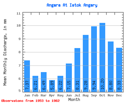
| Statistic | Jan | Feb | Mar | Apr | May | Jun | Jul | Aug | Sep | Oct | Nov | Dec | Annual |
|---|---|---|---|---|---|---|---|---|---|---|---|---|---|
| Mean | 7.37 | 6.26 | 6.49 | 5.89 | 6.22 | 7.14 | 8.31 | 9.28 | 9.94 | 10.20 | 8.80 | 8.32 | 94.16 |
| Standard Deviation | 1.27 | 1.08 | 1.39 | 1.32 | 1.19 | 0.81 | 1.21 | 1.74 | 1.60 | 1.89 | 1.25 | 1.62 | 11.04 |
| Min | 5.82 | 4.79 | 4.83 | 4.45 | 4.97 | 5.76 | 6.75 | 7.18 | 7.40 | 6.75 | 6.31 | 6.05 | 77.15 |
| Max | 9.43 | 7.74 | 8.91 | 8.17 | 7.97 | 8.26 | 10.74 | 12.19 | 11.80 | 13.09 | 10.76 | 10.69 | 109.25 |
| Coefficient of Variation | 0.17 | 0.17 | 0.21 | 0.22 | 0.19 | 0.11 | 0.15 | 0.19 | 0.16 | 0.18 | 0.14 | 0.20 | 0.12 |
 Return to R-Arctic Net Home Page