|
|
|||||||||||||||||
| Point ID: 8140 | Downloads | Plots | Site Data | Code: 7195 |
|
|
|||||||||||||||||
| Download | |
|---|---|
| Site Descriptor Information | Site Time Series Data |
| Link to all available data | |
| View: | Time Series | All |
| Units: | m3/s |
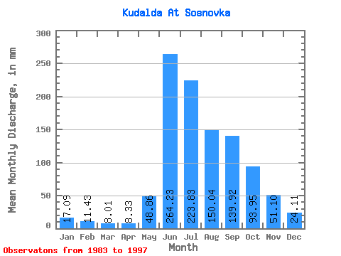
| Statistic | Jan | Feb | Mar | Apr | May | Jun | Jul | Aug | Sep | Oct | Nov | Dec | Annual |
|---|---|---|---|---|---|---|---|---|---|---|---|---|---|
| Mean | 17.09 | 11.52 | 8.01 | 8.32 | 48.85 | 264.23 | 223.80 | 150.00 | 139.92 | 93.94 | 51.10 | 24.11 | 1064.97 |
| Standard Deviation | 10.31 | 6.50 | 5.17 | 4.52 | 40.68 | 90.13 | 69.16 | 61.07 | 65.26 | 46.55 | 22.69 | 12.98 | 168.66 |
| Min | 1.43 | 3.79 | 2.54 | 1.59 | 11.08 | 85.13 | 135.52 | 71.57 | 52.29 | 21.93 | 9.38 | 4.17 | 838.93 |
| Max | 39.71 | 27.98 | 23.09 | 20.33 | 140.83 | 417.85 | 364.76 | 297.81 | 281.55 | 190.23 | 95.19 | 51.48 | 1446.27 |
| Coefficient of Variation | 0.60 | 0.56 | 0.65 | 0.54 | 0.83 | 0.34 | 0.31 | 0.41 | 0.47 | 0.49 | 0.44 | 0.54 | 0.16 |
 Return to R-Arctic Net Home Page