|
|
|||||||||||||||||
| Point ID: 813 | Downloads | Plots | Site Data | Code: 07OB007 |
|
|
|||||||||||||||||
| Download | |
|---|---|
| Site Descriptor Information | Site Time Series Data |
| Link to all available data | |
| View: | Time Series | All |
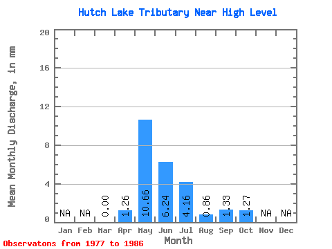
| Units: | m3/s |
| Statistic | Jan | Feb | Mar | Apr | May | Jun | Jul | Aug | Sep | Oct | Nov | Dec | Annual |
|---|---|---|---|---|---|---|---|---|---|---|---|---|---|
| Mean | 0.00 | 1.25 | 10.65 | 6.23 | 4.15 | 0.86 | 1.34 | 1.28 | |||||
| Standard Deviation | 0.00 | 0.98 | 12.01 | 7.97 | 6.97 | 1.17 | 1.74 | 1.88 | |||||
| Min | 0.00 | 0.15 | 0.16 | 0.03 | 0.00 | 0.00 | 0.00 | 0.00 | |||||
| Max | 0.00 | 2.89 | 37.70 | 23.23 | 20.02 | 3.61 | 4.88 | 5.46 | |||||
| Coefficient of Variation | 0.79 | 1.13 | 1.28 | 1.68 | 1.36 | 1.29 | 1.48 |
 Return to R-Arctic Net Home Page