|
|
|||||||||||||||||
| Point ID: 8129 | Downloads | Plots | Site Data | Code: 1619 |
|
|
|||||||||||||||||
| Download | |
|---|---|
| Site Descriptor Information | Site Time Series Data |
| Link to all available data | |
| View: | Time Series | All |
| Units: | m3/s |
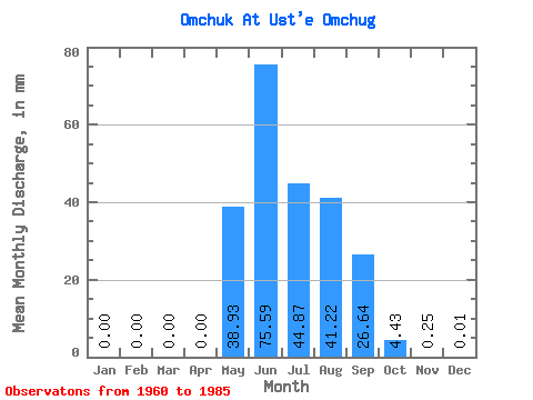
| Statistic | Jan | Feb | Mar | Apr | May | Jun | Jul | Aug | Sep | Oct | Nov | Dec | Annual |
|---|---|---|---|---|---|---|---|---|---|---|---|---|---|
| Mean | 0.00 | 0.00 | 0.00 | 0.00 | 38.92 | 75.59 | 44.86 | 41.21 | 26.64 | 4.43 | 0.25 | 0.01 | 231.10 |
| Standard Deviation | 0.00 | 0.00 | 0.00 | 0.00 | 26.17 | 46.07 | 30.02 | 24.74 | 17.42 | 4.69 | 0.29 | 0.03 | 64.88 |
| Min | 0.00 | 0.00 | 0.00 | 0.00 | 4.87 | 22.72 | 10.34 | 10.70 | 5.56 | 0.29 | 0.00 | 0.00 | 104.26 |
| Max | 0.00 | 0.00 | 0.00 | 0.00 | 120.81 | 180.51 | 150.67 | 105.19 | 74.25 | 24.90 | 0.98 | 0.14 | 405.67 |
| Coefficient of Variation | 0.67 | 0.61 | 0.67 | 0.60 | 0.65 | 1.06 | 1.13 | 2.41 | 0.28 |
 Return to R-Arctic Net Home Page