|
|
|||||||||||||||||
| Point ID: 812 | Downloads | Plots | Site Data | Code: 07OB006 |
|
|
|||||||||||||||||
| Download | |
|---|---|
| Site Descriptor Information | Site Time Series Data |
| Link to all available data | |
| View: | Time Series | All |
| Units: | m3/s |
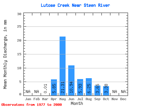
| Statistic | Jan | Feb | Mar | Apr | May | Jun | Jul | Aug | Sep | Oct | Nov | Dec | Annual |
|---|---|---|---|---|---|---|---|---|---|---|---|---|---|
| Mean | 0.01 | 5.85 | 21.31 | 10.94 | 5.94 | 6.24 | 3.64 | 3.38 | |||||
| Standard Deviation | 0.03 | 5.56 | 15.17 | 11.10 | 9.63 | 10.77 | 6.43 | 4.93 | |||||
| Min | 0.00 | 0.38 | 0.14 | 0.05 | 0.01 | 0.01 | 0.00 | 0.00 | |||||
| Max | 0.13 | 18.02 | 47.41 | 36.57 | 44.66 | 44.30 | 28.85 | 20.09 | |||||
| Coefficient of Variation | 2.37 | 0.95 | 0.71 | 1.01 | 1.62 | 1.73 | 1.76 | 1.46 |
 Return to R-Arctic Net Home Page