|
|
|||||||||||||||||
| Point ID: 8113 | Downloads | Plots | Site Data | Code: 1582 |
|
|
|||||||||||||||||
| Download | |
|---|---|
| Site Descriptor Information | Site Time Series Data |
| Link to all available data | |
| View: | Time Series | All |
| Units: | m3/s |
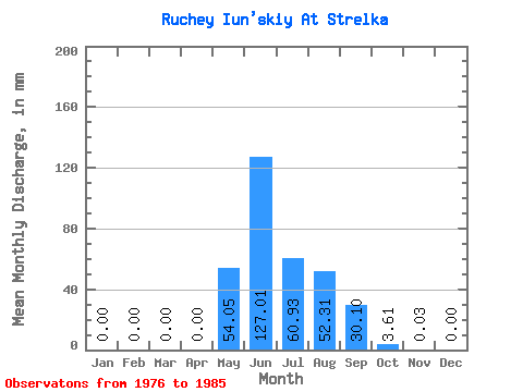
| Statistic | Jan | Feb | Mar | Apr | May | Jun | Jul | Aug | Sep | Oct | Nov | Dec | Annual |
|---|---|---|---|---|---|---|---|---|---|---|---|---|---|
| Mean | 0.00 | 0.00 | 0.00 | 0.01 | 54.05 | 127.01 | 60.92 | 52.30 | 30.10 | 3.61 | 0.03 | 0.00 | 327.27 |
| Standard Deviation | 0.00 | 0.00 | 0.00 | 0.02 | 30.88 | 70.92 | 46.46 | 28.15 | 21.24 | 2.07 | 0.07 | 0.00 | 100.15 |
| Min | 0.00 | 0.00 | 0.00 | 0.00 | 7.95 | 51.34 | 13.99 | 5.18 | 4.85 | 0.62 | 0.00 | 0.00 | 183.53 |
| Max | 0.00 | 0.00 | 0.00 | 0.05 | 85.35 | 240.81 | 171.05 | 104.87 | 61.37 | 7.78 | 0.23 | 0.00 | 483.67 |
| Coefficient of Variation | 3.16 | 0.57 | 0.56 | 0.76 | 0.54 | 0.70 | 0.57 | 2.19 | 0.31 |
 Return to R-Arctic Net Home Page