|
|
|||||||||||||||||
| Point ID: 8107 | Downloads | Plots | Site Data | Code: 1566 |
|
|
|||||||||||||||||
| Download | |
|---|---|
| Site Descriptor Information | Site Time Series Data |
| Link to all available data | |
| View: | Time Series | All |
| Units: | m3/s |
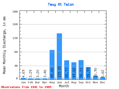
| Statistic | Jan | Feb | Mar | Apr | May | Jun | Jul | Aug | Sep | Oct | Nov | Dec | Annual |
|---|---|---|---|---|---|---|---|---|---|---|---|---|---|
| Mean | 4.69 | 3.32 | 3.20 | 3.46 | 85.64 | 133.85 | 55.76 | 49.62 | 56.21 | 35.99 | 10.90 | 6.62 | 436.28 |
| Standard Deviation | 2.54 | 1.66 | 1.23 | 1.61 | 35.37 | 79.96 | 31.51 | 26.23 | 32.76 | 23.45 | 4.50 | 3.01 | 101.84 |
| Min | 1.91 | 1.21 | 1.10 | 1.14 | 33.93 | 17.55 | 20.38 | 15.90 | 12.70 | 11.31 | 5.60 | 2.84 | 274.99 |
| Max | 11.31 | 7.99 | 4.92 | 5.86 | 185.65 | 362.47 | 170.71 | 112.03 | 140.44 | 102.53 | 20.03 | 12.80 | 681.82 |
| Coefficient of Variation | 0.54 | 0.50 | 0.38 | 0.46 | 0.41 | 0.60 | 0.56 | 0.53 | 0.58 | 0.65 | 0.41 | 0.46 | 0.23 |
 Return to R-Arctic Net Home Page