|
|
|||||||||||||||||
| Point ID: 8102 | Downloads | Plots | Site Data | Code: 1556 |
|
|
|||||||||||||||||
| Download | |
|---|---|
| Site Descriptor Information | Site Time Series Data |
| Link to all available data | |
| View: | Time Series | All |
| Units: | m3/s |
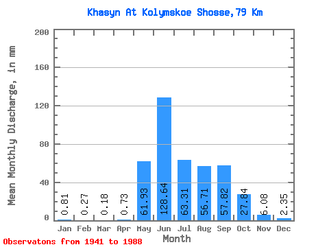
| Statistic | Jan | Feb | Mar | Apr | May | Jun | Jul | Aug | Sep | Oct | Nov | Dec | Annual |
|---|---|---|---|---|---|---|---|---|---|---|---|---|---|
| Mean | 0.81 | 0.28 | 0.19 | 0.73 | 61.92 | 128.64 | 63.30 | 56.71 | 57.82 | 27.83 | 6.08 | 2.35 | 405.69 |
| Standard Deviation | 1.22 | 0.69 | 0.53 | 0.61 | 31.04 | 74.29 | 32.72 | 32.52 | 31.11 | 21.11 | 2.98 | 1.64 | 117.17 |
| Min | 0.00 | 0.00 | 0.00 | 0.00 | 17.91 | 31.05 | 15.08 | 20.07 | 14.10 | 8.84 | 1.14 | 0.14 | 208.16 |
| Max | 6.17 | 3.36 | 2.47 | 2.21 | 178.66 | 391.46 | 163.35 | 153.54 | 130.74 | 95.81 | 13.30 | 7.93 | 753.91 |
| Coefficient of Variation | 1.50 | 2.50 | 2.84 | 0.84 | 0.50 | 0.58 | 0.52 | 0.57 | 0.54 | 0.76 | 0.49 | 0.70 | 0.29 |
 Return to R-Arctic Net Home Page