|
|
|||||||||||||||||
| Point ID: 8101 | Downloads | Plots | Site Data | Code: 1546 |
|
|
|||||||||||||||||
| Download | |
|---|---|
| Site Descriptor Information | Site Time Series Data |
| Link to all available data | |
| View: | Time Series | All |
| Units: | m3/s |
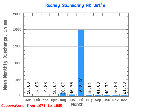
| Statistic | Jan | Feb | Mar | Apr | May | Jun | Jul | Aug | Sep | Oct | Nov | Dec | Annual |
|---|---|---|---|---|---|---|---|---|---|---|---|---|---|
| Mean | 19.07 | 14.88 | 14.77 | 16.55 | 80.65 | 47.15 | 1617.66 | 37.19 | 41.74 | 40.83 | 26.42 | 22.29 | 393.09 |
| Standard Deviation | 5.22 | 4.65 | 4.69 | 5.07 | 35.24 | 33.34 | 6137.81 | 13.36 | 14.23 | 13.48 | 8.57 | 5.95 | 77.94 |
| Min | 14.10 | 10.70 | 9.40 | 11.37 | 31.32 | 21.22 | 18.79 | 23.49 | 27.28 | 23.49 | 15.92 | 15.66 | 273.46 |
| Max | 30.54 | 27.11 | 26.62 | 31.53 | 143.30 | 143.24 | 23804.44 | 68.12 | 73.52 | 65.78 | 44.72 | 32.89 | 565.68 |
| Coefficient of Variation | 0.27 | 0.31 | 0.32 | 0.31 | 0.44 | 0.71 | 3.79 | 0.36 | 0.34 | 0.33 | 0.32 | 0.27 | 0.20 |
 Return to R-Arctic Net Home Page