|
|
|||||||||||||||||
| Point ID: 8093 | Downloads | Plots | Site Data | Code: 1522 |
|
|
|||||||||||||||||
| Download | |
|---|---|
| Site Descriptor Information | Site Time Series Data |
| Link to all available data | |
| View: | Time Series | All |
| Units: | m3/s |
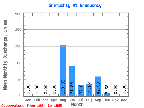
| Statistic | Jan | Feb | Mar | Apr | May | Jun | Jul | Aug | Sep | Oct | Nov | Dec | Annual |
|---|---|---|---|---|---|---|---|---|---|---|---|---|---|
| Mean | 0.00 | 0.00 | 0.00 | 0.00 | 123.10 | 71.77 | 27.00 | 29.89 | 48.04 | 7.49 | 0.00 | 0.00 | 301.78 |
| Standard Deviation | 0.00 | 0.00 | 0.00 | 0.00 | 56.77 | 44.44 | 31.14 | 27.45 | 58.92 | 8.35 | 0.00 | 0.00 | 127.05 |
| Min | 0.00 | 0.00 | 0.00 | 0.00 | 32.09 | 10.27 | 0.25 | 0.00 | 1.47 | 0.25 | 0.00 | 0.00 | 135.22 |
| Max | 0.00 | 0.00 | 0.00 | 0.00 | 280.43 | 166.03 | 133.40 | 103.33 | 235.24 | 27.79 | 0.00 | 0.00 | 587.93 |
| Coefficient of Variation | 0.46 | 0.62 | 1.15 | 0.92 | 1.23 | 1.11 | 0.42 |
 Return to R-Arctic Net Home Page