|
|
|||||||||||||||||
| Point ID: 808 | Downloads | Plots | Site Data | Code: 07OA001 |
|
|
|||||||||||||||||
| Download | |
|---|---|
| Site Descriptor Information | Site Time Series Data |
| Link to all available data | |
| View: | Time Series | All |
| Units: | m3/s |
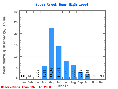
| Statistic | Jan | Feb | Mar | Apr | May | Jun | Jul | Aug | Sep | Oct | Nov | Dec | Annual |
|---|---|---|---|---|---|---|---|---|---|---|---|---|---|
| Mean | 0.07 | 5.98 | 22.34 | 14.47 | 8.02 | 6.32 | 3.17 | 2.56 | |||||
| Standard Deviation | 0.18 | 6.21 | 18.42 | 18.31 | 10.26 | 9.81 | 4.61 | 3.54 | |||||
| Min | 0.00 | 0.04 | 0.38 | 0.38 | 0.04 | 0.02 | 0.01 | 0.02 | |||||
| Max | 0.91 | 30.41 | 65.07 | 88.93 | 48.39 | 32.04 | 19.02 | 13.21 | |||||
| Coefficient of Variation | 2.53 | 1.04 | 0.82 | 1.27 | 1.28 | 1.55 | 1.45 | 1.38 |
 Return to R-Arctic Net Home Page