|
|
|||||||||||||||||
| Point ID: 8079 | Downloads | Plots | Site Data | Code: 1451 |
|
|
|||||||||||||||||
| Download | |
|---|---|
| Site Descriptor Information | Site Time Series Data |
| Link to all available data | |
| View: | Time Series | All |
| Units: | m3/s |
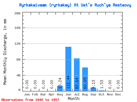
| Statistic | Jan | Feb | Mar | Apr | May | Jun | Jul | Aug | Sep | Oct | Nov | Dec | Annual |
|---|---|---|---|---|---|---|---|---|---|---|---|---|---|
| Mean | 0.00 | 0.00 | 0.00 | 0.00 | 13.22 | 112.43 | 82.62 | 60.08 | 9.13 | 1.54 | 0.00 | 0.00 | 277.37 |
| Standard Deviation | 0.00 | 0.00 | 0.00 | 0.00 | 18.03 | 33.67 | 60.82 | 40.88 | 7.04 | 3.17 | 0.01 | 0.00 | 94.20 |
| Min | 0.00 | 0.00 | 0.00 | 0.00 | 0.00 | 64.67 | 31.98 | 14.30 | 1.54 | 0.08 | 0.00 | 0.00 | 170.59 |
| Max | 0.00 | 0.00 | 0.00 | 0.00 | 65.26 | 187.24 | 253.53 | 162.78 | 25.18 | 13.26 | 0.05 | 0.00 | 500.96 |
| Coefficient of Variation | 1.36 | 0.30 | 0.74 | 0.68 | 0.77 | 2.06 | 4.00 | 0.34 |
 Return to R-Arctic Net Home Page