|
|
|||||||||||||||||
| Point ID: 8070 | Downloads | Plots | Site Data | Code: 1409 |
|
|
|||||||||||||||||
| Download | |
|---|---|
| Site Descriptor Information | Site Time Series Data |
| Link to all available data | |
| View: | Time Series | All |
| Units: | m3/s |
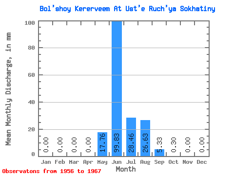
| Statistic | Jan | Feb | Mar | Apr | May | Jun | Jul | Aug | Sep | Oct | Nov | Dec | Annual |
|---|---|---|---|---|---|---|---|---|---|---|---|---|---|
| Mean | 0.00 | 0.00 | 0.00 | 0.00 | 17.75 | 99.83 | 28.45 | 26.62 | 5.33 | 0.30 | 0.00 | 0.00 | 178.52 |
| Standard Deviation | 0.00 | 0.00 | 0.00 | 0.00 | 31.80 | 40.17 | 14.44 | 15.18 | 4.70 | 0.22 | 0.00 | 0.00 | 43.81 |
| Min | 0.00 | 0.00 | 0.00 | 0.00 | 0.03 | 52.38 | 11.43 | 8.14 | 1.59 | 0.09 | 0.00 | 0.00 | 119.93 |
| Max | 0.00 | 0.00 | 0.00 | 0.00 | 110.26 | 170.89 | 57.62 | 48.57 | 17.77 | 0.70 | 0.01 | 0.00 | 253.80 |
| Coefficient of Variation | 1.79 | 0.40 | 0.51 | 0.57 | 0.88 | 0.73 | 2.28 | 0.24 |
 Return to R-Arctic Net Home Page