|
|
|||||||||||||||||
| Point ID: 8065 | Downloads | Plots | Site Data | Code: 1350 |
|
|
|||||||||||||||||
| Download | |
|---|---|
| Site Descriptor Information | Site Time Series Data |
| Link to all available data | |
| View: | Time Series | All |
| Units: | m3/s |
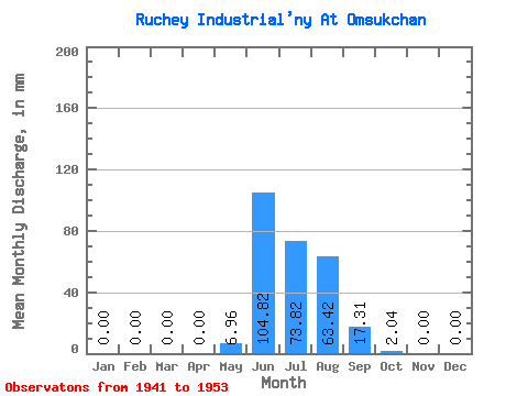
| Statistic | Jan | Feb | Mar | Apr | May | Jun | Jul | Aug | Sep | Oct | Nov | Dec | Annual |
|---|---|---|---|---|---|---|---|---|---|---|---|---|---|
| Mean | 0.00 | 0.00 | 0.00 | 0.00 | 6.94 | 104.83 | 73.84 | 63.43 | 17.29 | 2.08 | 0.00 | 0.00 | 267.56 |
| Standard Deviation | 0.00 | 0.00 | 0.00 | 0.00 | 10.52 | 46.35 | 26.54 | 25.09 | 11.28 | 3.20 | 0.00 | 0.00 | 56.01 |
| Min | 0.00 | 0.00 | 0.00 | 0.00 | 0.00 | 41.47 | 38.56 | 31.07 | 5.97 | 0.00 | 0.00 | 0.00 | 142.29 |
| Max | 0.00 | 0.00 | 0.00 | 0.00 | 28.92 | 191.81 | 129.72 | 95.34 | 37.33 | 10.50 | 0.00 | 0.00 | 328.22 |
| Coefficient of Variation | 1.52 | 0.44 | 0.36 | 0.40 | 0.65 | 1.54 | 0.21 |
 Return to R-Arctic Net Home Page