|
|
|||||||||||||||||
| Point ID: 8056 | Downloads | Plots | Site Data | Code: 1203 |
|
|
|||||||||||||||||
| Download | |
|---|---|
| Site Descriptor Information | Site Time Series Data |
| Link to all available data | |
| View: | Time Series | All |
| Units: | m3/s |
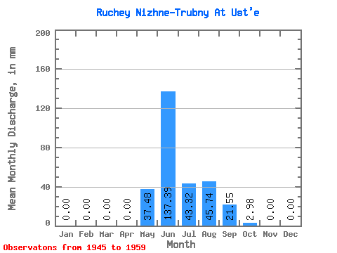
| Statistic | Jan | Feb | Mar | Apr | May | Jun | Jul | Aug | Sep | Oct | Nov | Dec | Annual |
|---|---|---|---|---|---|---|---|---|---|---|---|---|---|
| Mean | 0.00 | 0.00 | 0.00 | 0.00 | 37.47 | 137.41 | 43.28 | 45.78 | 21.54 | 3.01 | 0.00 | 0.00 | 288.49 |
| Standard Deviation | 0.00 | 0.00 | 0.00 | 0.00 | 28.74 | 61.76 | 18.62 | 19.91 | 11.23 | 1.91 | 0.00 | 0.00 | 75.17 |
| Min | 0.00 | 0.00 | 0.00 | 0.00 | 0.00 | 41.60 | 17.63 | 17.63 | 9.71 | 1.21 | 0.00 | 0.00 | 126.74 |
| Max | 0.00 | 0.00 | 0.00 | 0.00 | 79.35 | 234.67 | 76.04 | 74.94 | 46.93 | 6.61 | 0.00 | 0.00 | 370.69 |
| Coefficient of Variation | 0.77 | 0.45 | 0.43 | 0.43 | 0.52 | 0.64 | 0.26 |
 Return to R-Arctic Net Home Page