|
|
|||||||||||||||||
| Point ID: 8031 | Downloads | Plots | Site Data | Code: 1038 |
|
|
|||||||||||||||||
| Download | |
|---|---|
| Site Descriptor Information | Site Time Series Data |
| Link to all available data | |
| View: | Time Series | All |
| Units: | m3/s |
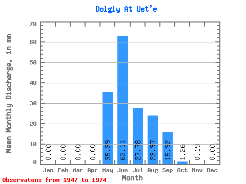
| Statistic | Jan | Feb | Mar | Apr | May | Jun | Jul | Aug | Sep | Oct | Nov | Dec | Annual |
|---|---|---|---|---|---|---|---|---|---|---|---|---|---|
| Mean | 0.00 | 0.00 | 0.00 | 0.00 | 35.38 | 63.11 | 27.77 | 23.97 | 15.92 | 1.27 | 0.19 | 0.00 | 167.19 |
| Standard Deviation | 0.00 | 0.00 | 0.00 | 0.00 | 25.01 | 45.70 | 21.18 | 16.47 | 11.97 | 1.42 | 0.41 | 0.00 | 54.58 |
| Min | 0.00 | 0.00 | 0.00 | 0.00 | 7.29 | 15.75 | 4.24 | 4.41 | 2.13 | 0.44 | 0.00 | 0.00 | 76.13 |
| Max | 0.00 | 0.00 | 0.00 | 0.00 | 118.65 | 191.12 | 78.39 | 74.41 | 47.00 | 8.14 | 1.72 | 0.02 | 290.86 |
| Coefficient of Variation | 0.71 | 0.72 | 0.76 | 0.69 | 0.75 | 1.12 | 2.17 | 3.88 | 0.33 |
 Return to R-Arctic Net Home Page