|
|
|||||||||||||||||
| Point ID: 802 | Downloads | Plots | Site Data | Code: 07KE001 |
|
|
|||||||||||||||||
| Download | |
|---|---|
| Site Descriptor Information | Site Time Series Data |
| Link to all available data | |
| View: | Time Series | All |
| Units: | m3/s |
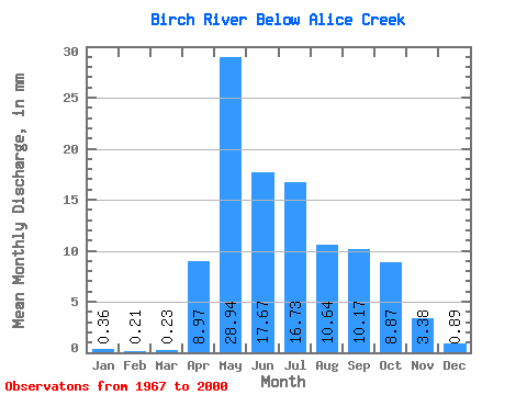
| Statistic | Jan | Feb | Mar | Apr | May | Jun | Jul | Aug | Sep | Oct | Nov | Dec | Annual |
|---|---|---|---|---|---|---|---|---|---|---|---|---|---|
| Mean | 0.36 | 0.21 | 0.23 | 8.97 | 28.94 | 17.67 | 16.73 | 10.64 | 10.17 | 8.87 | 3.38 | 0.89 | 101.02 |
| Standard Deviation | 0.20 | 0.10 | 0.14 | 7.79 | 18.37 | 14.80 | 15.80 | 10.34 | 12.95 | 10.95 | 2.94 | 0.64 | 53.44 |
| Min | 0.08 | 0.05 | 0.05 | 0.30 | 1.66 | 2.71 | 1.24 | 0.62 | 0.40 | 0.72 | 0.41 | 0.18 | 33.15 |
| Max | 0.91 | 0.46 | 0.54 | 32.86 | 73.06 | 58.88 | 60.30 | 46.72 | 57.05 | 48.62 | 9.80 | 1.99 | 215.91 |
| Coefficient of Variation | 0.56 | 0.47 | 0.59 | 0.87 | 0.64 | 0.84 | 0.94 | 0.97 | 1.27 | 1.23 | 0.87 | 0.71 | 0.53 |
 Return to R-Arctic Net Home Page