|
|
|||||||||||||||||
| Point ID: 7966 | Downloads | Plots | Site Data | Code: 3606 |
|
|
|||||||||||||||||
| Download | |
|---|---|
| Site Descriptor Information | Site Time Series Data |
| Link to all available data | |
| View: | Time Series | All |
| Units: | m3/s |
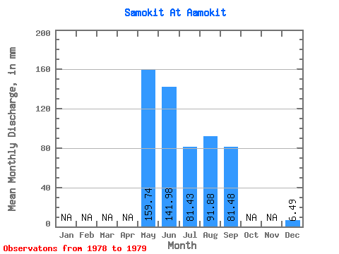
| Statistic | Jan | Feb | Mar | Apr | May | Jun | Jul | Aug | Sep | Oct | Nov | Dec | Annual |
|---|---|---|---|---|---|---|---|---|---|---|---|---|---|
| Mean | 159.72 | 141.98 | 81.42 | 91.87 | 81.48 | 6.49 | |||||||
| Standard Deviation | 0.00 | 95.09 | 43.65 | 67.08 | |||||||||
| Min | 159.72 | 74.74 | 50.56 | 44.43 | 81.48 | 6.49 | |||||||
| Max | 159.72 | 209.22 | 112.28 | 139.30 | 81.48 | 6.49 | |||||||
| Coefficient of Variation | 0.00 | 0.67 | 0.54 | 0.73 |
 Return to R-Arctic Net Home Page