|
|
|||||||||||||||||
| Point ID: 7963 | Downloads | Plots | Site Data | Code: 3602 |
|
|
|||||||||||||||||
| Download | |
|---|---|
| Site Descriptor Information | Site Time Series Data |
| Link to all available data | |
| View: | Time Series | All |
| Units: | m3/s |
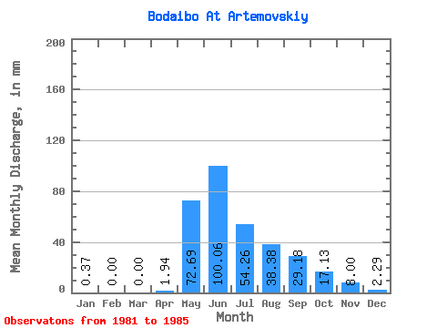
| Statistic | Jan | Feb | Mar | Apr | May | Jun | Jul | Aug | Sep | Oct | Nov | Dec | Annual |
|---|---|---|---|---|---|---|---|---|---|---|---|---|---|
| Mean | 0.36 | 0.00 | 0.00 | 1.94 | 72.67 | 100.06 | 54.25 | 38.37 | 29.18 | 17.13 | 8.00 | 2.28 | 322.98 |
| Standard Deviation | 0.65 | 0.00 | 0.00 | 2.62 | 19.93 | 37.49 | 29.30 | 25.15 | 13.97 | 5.99 | 4.63 | 2.08 | 96.38 |
| Min | 0.00 | 0.00 | 0.00 | 0.00 | 55.18 | 65.69 | 18.24 | 9.93 | 16.09 | 8.54 | 2.91 | 0.02 | 206.14 |
| Max | 1.50 | 0.00 | 0.00 | 6.48 | 105.04 | 152.39 | 94.42 | 66.95 | 46.48 | 24.93 | 12.30 | 4.62 | 431.91 |
| Coefficient of Variation | 1.78 | 1.35 | 0.27 | 0.38 | 0.54 | 0.66 | 0.48 | 0.35 | 0.58 | 0.92 | 0.30 |
 Return to R-Arctic Net Home Page