|
|
|||||||||||||||||
| Point ID: 7957 | Downloads | Plots | Site Data | Code: 3595 |
|
|
|||||||||||||||||
| Download | |
|---|---|
| Site Descriptor Information | Site Time Series Data |
| Link to all available data | |
| View: | Time Series | All |
| Units: | m3/s |
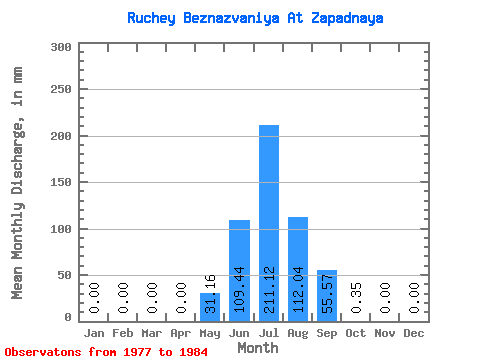
| Statistic | Jan | Feb | Mar | Apr | May | Jun | Jul | Aug | Sep | Oct | Nov | Dec | Annual |
|---|---|---|---|---|---|---|---|---|---|---|---|---|---|
| Mean | 0.00 | 0.00 | 0.00 | 0.00 | 31.11 | 109.49 | 211.19 | 111.95 | 55.62 | 0.30 | 0.00 | 0.00 | 515.66 |
| Standard Deviation | 0.00 | 0.00 | 0.00 | 0.00 | 16.58 | 99.74 | 145.06 | 103.14 | 60.61 | 0.65 | 0.00 | 0.00 | 329.25 |
| Min | 0.00 | 0.00 | 0.00 | 0.00 | 9.10 | 21.01 | 59.86 | 3.01 | 0.00 | 0.00 | 0.00 | 0.00 | 155.46 |
| Max | 0.00 | 0.00 | 0.00 | 0.00 | 52.51 | 325.27 | 392.07 | 315.06 | 138.92 | 1.75 | 0.00 | 0.00 | 1151.91 |
| Coefficient of Variation | 0.53 | 0.91 | 0.69 | 0.92 | 1.09 | 2.17 | 0.64 |
 Return to R-Arctic Net Home Page