|
|
|||||||||||||||||
| Point ID: 795 | Downloads | Plots | Site Data | Code: 07JD003 |
|
|
|||||||||||||||||
| Download | |
|---|---|
| Site Descriptor Information | Site Time Series Data |
| Link to all available data | |
| View: | Time Series | All |
| Units: | m3/s |
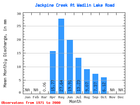
| Statistic | Jan | Feb | Mar | Apr | May | Jun | Jul | Aug | Sep | Oct | Nov | Dec | Annual |
|---|---|---|---|---|---|---|---|---|---|---|---|---|---|
| Mean | 0.06 | 15.77 | 27.63 | 19.91 | 13.23 | 9.07 | 7.37 | 6.12 | |||||
| Standard Deviation | 0.12 | 12.08 | 21.02 | 18.84 | 15.82 | 13.89 | 11.37 | 8.69 | |||||
| Min | 0.00 | 1.82 | 1.52 | 1.11 | 0.10 | 0.04 | 0.00 | 0.05 | |||||
| Max | 0.56 | 53.44 | 84.67 | 70.81 | 69.02 | 58.44 | 47.21 | 41.64 | |||||
| Coefficient of Variation | 2.04 | 0.77 | 0.76 | 0.95 | 1.20 | 1.53 | 1.54 | 1.42 |
 Return to R-Arctic Net Home Page